The World Cocoa Foundation (WCF), together with the Alliance of Bioversity International and CIAT, has published the Active Deforestation Risk Assessment (DRA) Methodology for cocoa, the sector's first real attempt at a shared, step-by-step framework for assessing deforestation risk under the EU Deforestation Regulation.
The methodology was developed through a multi-stakeholder process involving cocoa companies, producing-country stakeholders, technical experts, compliance providers and public authorities. It structures deforestation risk assessment around a series of stages, from plot data quality through to mitigation and corrective action.
At Meridia, this maps closely onto how we already work, either directly through our platform, Verify, or through bespoke work delivered by our Advisory team. Here's how it breaks down.
Plot data quality and geometry checks
WCF sets out a structured path from raw plot data to a curated, analysis-ready database: point quality checks, administrative consistency, contextual overlays, geometry consistency, polygon overlap management, and visual inspection.
Meridia has run this ground extensively for some time. Incoming plot data is accepted in whatever format a client provides and converted to a common, country-appropriate map projection, invalid or broken shapes are automatically repaired, and a wide range of automated checks then runs across every plot, flagging bad geometry, inconsistent boundaries, implausible shapes, and incomplete or inconsistent attribute data. It's the same underlying discipline, just organised around our own set of checks rather than a single named pipeline.
Buffering point-based farm plots
Smallholder cocoa farms are frequently mapped as a single GPS point rather than a full boundary polygon. WCF's methodology treats this carefully: it allows points for plots under 4 hectares, but recommends buffer analysis for risk interpretation, using an area of one to two times the reported plot size, with clear limitations flagged.
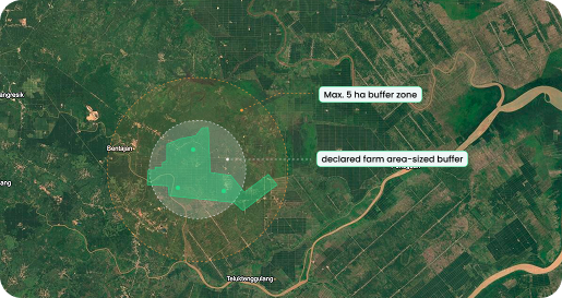
Meridia has recently applied a buffered approach to point-based plots: we draw a buffer around the point sized at twice the farmer's declared plot area, capped at 5 hectares, and run the same deforestation checks against that buffer as we would against a full boundary. If no plot size is reported, we default to a 5-hectare buffer. This was shaped independently from WCF, with input from ICE CoT's technical working group, and it lands on the same double-the-area logic WCF's methodology now recommends, with an added, more conservative cap.
Deforestation overlay analysis
Meridia's deforestation tests are built on maps, which are fully aligned to EUDR's definitions: a 2020 forest baseline is established, other land uses including agricultural land are excluded from it, and deforestation is only flagged where an area converts from forest to a non-forest use. These maps are the basis for our deforestation tests, and results are reported in detail, including the relative and absolute area of overlap for polygon plots. For point-based plots, results are calculated both with and without a buffer, with the buffered calculation reflecting the recommended best practice under WCF's methodology.
That means Verify's overlay analysis meets WCF's core requirements and follows its recommended best practice.
ICE CoT EUDR Deforestation Map. Produced by Space Intelligence for use in the ICE CoT platform. Licensed by ICE Benchmark Administration Limited
Legal zoning and protected areas
WCF describes legal zoning as its own dedicated step: compiling official zoning layers, intersecting them with plot boundaries, identifying overlaps, and classifying each plot's legal status accordingly. It's explicit that national datasets are authoritative, and that legal constraints can be stricter than EUDR itself.
Meridia already runs this kind of analysis, checking plots against global protected-area datasets and indigenous and local community territories, with each area classified into one of four risk tiers. Country-level legal categorisations are reviewed jointly with ICE and KPMG before they're finalised, an external validation step WCF's methodology doesn't itself require.
Verification
WCF sets out four verification activities: confirming flagged cases using high-resolution imagery, drawing on ancillary data, conducting field visits, and documenting every verification activity. Meridia covers all four, though not all of them through the same channel.
High-resolution imagery verification is available directly in Verify, through our Visual Inspection feature: PlanetScope and Sentinel-2 imagery, with a historical timeline spanning the EUDR cut-off date, built into the platform so flagged plots can be reviewed without leaving it. Where a client needs a deeper desk-based review than the self-serve tool provides, our Advisory team can also take this on as a bespoke engagement.
Ancillary data verification and field visits are delivered as bespoke services through Advisory, following standard procedures and protocols for desk and filed investigations. Every verification outcome can be logged via our reclassification and resolution workflows: the outcomes are linked to the affected farm plots with the supporting evidence attached directly in the platform, so the documentation requirement is met throughout.
Mitigation and corrective action
Where WCF sets out a structured path for handling non-compliant plots (verification, corrective action, re-assessment), Meridia already runs a comparable protocol. Our resolution protocols cover everything from data quality fixes to full geopoint-to-polygon remapping, and our Farmplot Reclassification workflow lets clients upload supporting evidence and record an outcome, risk mitigated, or false positive, for any flagged plot. Where mitigation isn't possible, our protocols support excluding the affected plots from EU-bound supply chains, in line with Accountability Framework initiative principles on proportionate action.
What this means if you're evaluating a compliance partner
Standards like WCF's give the industry a shared language for what "good" looks like. Across the areas covered here, Meridia's approach already reflects that standard whether through Verify directly or through bespoke work from our Advisory team, and in some cases with additional external validation, including an independent audit by EY, that the methodology itself doesn't require.
Meridia works closely with ICE CoT, an end-to-end EUDR compliance solution, with Meridia Verify providing the upstream farm-plot data verification and risk assessment that feeds into it.